 |
| Chief Peak |
Feeling trapped inside the last month from work and rain to say I was eager to get outside would be a bit of an understatement. Surely some long miles and some good old fashion butt kicking elevation gain would cure what was ailing me. Joined with
eric_hikes84 we decided to tackle Chief Peak Via the Horn Canyon Trail (22W08), which takes off from behind thatcher school in Ojai. Signage is not very good for finding the parking area, if you make a right on the first paved street before the school (McAndrew Rd) you can follow that for .2 mile through a residential neighborhood then hang a left on forest route 5N10 also called Horn Canyon road and in .4 mile or less you arrive at the Trail-head
CLICK HERE FOR HORN CYN PARKING GOOGLE MAP. There is parking in front of the Trail-Head sign and multiple spots along the road in front of the white gate. One Portable toilet is located adjacent to the Trail-head sign hiding among the trees.
 |
| Horn Canyon Trail-Head |
 |
| Trail-Head facilities |
 |
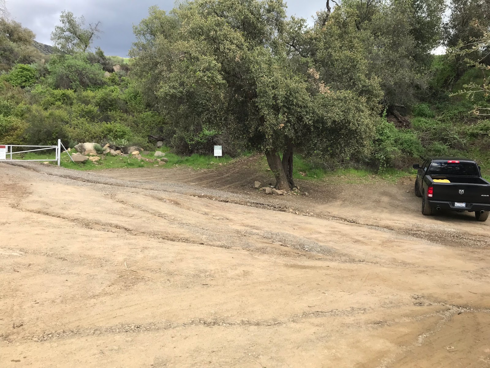
| Parking Area |
Alternatively if you miss the residential right turn and end up driving straight on to the school grounds stay heading right on Thatcher Road and pass the staff parking lot shorty on your right you will see a small sign that reads Horn Canyon Trail Access (see photos below). Across from that sign to your left is another dirt parking area. The walk from here to the Trail-Head is short less than .2 mile. Keep in mind You will have to cross the creek if you end up parking here. Currently water is really flowing good along Thatcher creek, but a high clearance 4 wheel drive vehicle could by pass this parking area and drive straight on thatcher Road directly to the Trail-Head. (My mileage on this trip starts from this alternate parking area).
 |
| Horn Canyon Trail access sign |
 |
| Alternate parking area near the school |
 |
| Thatcher Road Creek crossing |
According to the Fine folks over at
Hike Los Padres this trail was one of the early major routes used by hunters, campers, and fisherman to travel from Ojai to the Sespe River. The trail is well maintained and easy to follow. Come prepared for a work out, it is an all out uphill battle to the top of Horn Canyon. Sections of the trail become steep and narrow, you will cross the creek 4 times. Unless you have perfected the trekking pole catapult method your getting your boots wet.
 |
| Beginning your accent of horn Canyon, the valley is so nice and green right now |
 |
| Look at the flow along Thatcher Creek I'm loving our current water situation |
Around 1.3 miles in you will pass what looks to be the ruins of an old cabin. I have no idea what this building once was so if anyone reading this does please leave a comment.
 |
| Cabin Ruins and Lacy with her new Ruffwear jacket |
 |
| Eric making his way up the canyon |
 |
| Hello Ojai what a view |
This was my first hike with Eric and I'll admit I pushed the pace hard and fast all the way up to Sisar Rd. I Wanted to see what he was made of. He had some initial reservations about his current fitness level and I'm a bit hesitant these days about going out with new people. However by the end the day I knew I could hike with Eric anytime, he did well and was great trail company.
 |
| The Pines Camp Overview |
 |
| The Pines site #1 |
 |
| Looking Down on The Pines Camp from above |
Around 1800 feet of elevation gain and 2.8 miles later you come to The Pines Camp. This was once a beautiful Conifer shaded trail Camp with water piped in from a spring behind it and some fancy wood worked benches courtesy of the fire Department. Today it is none of those things. I was saddened to see the current state of affairs here. Fires, previous droughts and bark beetles have destroyed the trees. The trough was dry and the piping from the spring is no longer viable. ( If camping here plan on bringing your own water as access will not be convenient from Camp). Currently there are 3 sites available, site 1 and 2 have the camp grills. Site 3 has only a rock fire ring. The camp is in desperate need of brushing, so you will want to be extra careful with your campfire and tent placement under one of the few remaining burned pines might not be the best idea. I'm all in for helping bring this camp back to life should the
LPFA consider a project here. Or maybe even some ambitious boy scouts could spruce it back up. Many years ago the forest service established a tree nursery here and the students of Thatcher School have taken part in the replanting of trees. Fingers crossed that hopefully something is in the works.
 |
| The Pines site #2 |
 |
| The Pines site #3 |
Dry Trough and definitely no water coming out of that spigot
After leaving The Pines it's back to the grind. Another 1500 feet of elevation gain in under 2 miles and you reach the junction with Sisar Road. (mile marker 4.6). Hang a left here and its all fire roads for the rest of the way until the spur trail that takes you too the Peak.
 |
| Horn Cyn & Sisar Rd Junction |
 |
| Sisar and Nordhoff junction |
Following Sisar Road in just under a mile you connect with Nordhoff Ridge road. Again stay left and continue onto Nordhoff Rd. The walk along this ridge is exposed however this time of year the weather was perfect and the sun rays were welcoming. As you make your way toward Chief your gifted with some really nice views of the surrounding area. Also right now just about every tributary coming off this range had flowing water as did the spring pond directly below Chief Peak.
 |
| A Look at Chief Peak from Nordhoff Ridge |
 |
| Spring Pond under the summit of Chief Peak |
As you start to make your way directly under the peak and at about 7.1 miles in on your left side look for the spur trail/possibly maybe old Dozer cut.(N34° 30' 19.2" W119° 10' 16.8") Here exit the fire road and follow this route onto the ridge and up to the Summit. Note: trail is not well defined it's kind of a pick your own path. The last section of less than .3 mile is a bit of a scramble, use caution if you have your dog with you. I had to zig zag a bit and carefully plan my accent to make sure my pup could get up without hurting her paws. As you can see from the map below I exited a little different line than I went up, again only because I had to keep my pup safe.
 |
| Exit fire road here notice the stacked rocks marking the spur trail |
 |
| The Boulder Scramble |
 |
| View North from Chief Peak toward the Sespe |
As would be expected the views from the summit were incredible especially down toward the Sespe. One thing to note is the Plastic summit register can appears to have had some small holes chewed in it. All of the old entry's are now soaked with water. If you plan on visiting here please bring along a new register can.
 |
| Summit register |
 |
| USGS Survey Marker |
Stats for the day according to my Garmin put us at 15.2 miles round trip with 4,739 feet of elevation gain. Sore legs YES I had them the next day. By most standards this one is a beast.
 |
| Obligatory Summit Pic |
 |
| Eric in the clouds |
Don't wait for the weather to get to hot, if this one is on your short list go get it. Currently the combo of water and weather cant be beat. I had an absolute blast as usual Lost In The Los Padres. Click on any picture to enlarge it, GPS track and KMZ file are available for download below. If you got comments please leave them I love hearing from you all.


13 comments:
looks fabulous and as always think you so much for sharing this with us I don't think I'm going to try this one but sure looks tempting thanks again Chris
Thanks for reading Love you Gram
Great report! We were the group chatting you up at The Pines. Amazing views of Ojai from there, but yes, sad how destructive the fires have been. Still an incredible hike. Flowers will be coming out soon!
Nice read ❤️
Thanks Love
Hey Jeff it was great meeting you thanks for reading
Nice! I stayed the night at The Pines for the first time back in January. It was a cold & windy night. We woke up to snow being blown down from the backside of Nordhoff ridge. I bet this use to be an amazing spot. Burnt up or not the sunsets here are hard to beat. I'd be happy to help with restoration if you get something lined up. Also if you follow a trail to the left past the old water trough you can make your way down into a side canyon & up to an old spring, that's where we collected water from. We got lucky that a teacher from Thatcher happened to be going for an evening hike & he showed me the way to it, other wise we would of had to hike all the way back down to the creek. When i was there i wondered how far it was to Chief Peak, thanks for answering that for me.
Hey Reece yeah I read a report from Craig about accessing water north of Camp down the ravine, but left out mention of it since I dint go see it for myself. Glad to know its there and available thanks for sharing.
that was anice challenging route. keep em coming
Good Times For sure
Nice report. One other variation of this trip is to come down the Twin Peaks ridge to make it a loop. I did this back in October; there is only relatively minor bushwacking (thanks to the Thomas fire) along the Twin Peaks ridge, but it is a rough yet worthwhile route.
Thanks Kris I will have to check that out sometime
Post a Comment