|
| San Rafael Peak (Sespe Wilderness) |
I don't consider myself much of a peak bagger however when August temps are cooking I tend to look for higher ground and the Grade Valley/Mutau area has plenty of that. Not to mention it is just an incredible part of the forest that I never tire of. I was gonna check off San Rafael a few months ago, but decided to save it (along with a few other spots) for summer knowing that the heat would limit my options. Little Mutau Trail Camp has not had an official FS survey that I have seen since Kim Coakley's back in May of 2012 so it was definitely past due for the 5 year mark. A decision was made to link up both spots together for a partial loop trip, here's how it went. (Click on any picture to enlarge).
 |
| Johnston Ridge Trailhead |
Reece and I rolled up to the Johnston Ridge Trailhead (our take off point) around 7:30 am on Sunday August 11th 2019. The Trailhead here has about 5 parking spaces, 2 vault toilets, informative signs, and provides access to The Stonehouse Trail (20W35), Johnston Ridge Trail (20W12) and the trail we would be following Little Mutau (20W10). If your planning a visit keep in mind the Piru Road crossing on Grade Valley Road shortly after Fishbowls still has a good amount of water so a high clearance vehicle is needed to get back all the way.
 |
| Trail takes off here |
From here follow the trail out of the Northeast corner of the parking lot past the signs pictured above. In 1.4 miles you will come to the junction with Stonehouse Trail. This area has a few short reroutes from fallen trees the northern route leads you right to the junction sign. The southern one dumps you about 400 feet up the Stonehouse Trail to which you will need to make a right and head toward the Ranch gate and back onto Little Mutau.
Here you officially enter the Sespe Wilderness continue on past the boundary sign and within about 500 feet you will cross Mutau Creek. As you can see from the photo below water was still flowing. The expansive Ranch land to your south was once used as a cattle grazing area by local pioneers, because of its remote location it is said to have once been a holding area for cattle rustlers and horse thieves. The property is now in private hands and no longer accessible to the public, but do admire the stunning views.
 |
| Mutau Creek |
After crossing the Creek you begin the ascent up the eastern ravine along Little Mutau Trail and in less than a mile you arrive at the Junction with Johnston Ridge Trail. A right turn here would eventually take you to the infamous Sespe Hot Springs, while not on our agenda today, most likely coming soon. Skip on past the sign and continue upward.
 |
| Little Mutau/Johnston Ridge Junction |
 |
| View of Mutau Flat from the switchbacks. |
As you climb your afforded some excellent views back toward Mutau Flat. The trail is in much better shape than I expected. For the most part very easy to follow, with only a handful of downed trees and a few sporadic sections that require a decent amount of brushing. Mark and Bryan if you're reading this a trail survey should be hitting your inbox within the next week.
 |
| Where we exited Little Mutau and made our way up toward San Rafael Peak |
At approximately the 3.6 mile mark pictured above is where we exited the main trail and began to make our way toward the Peak. San Rafael is one of the Sierra Club Hundred Peaks Section Hikes (HPS) and so does get a fair amount of use. With careful attention paid and knowing your surroundings one can mostly follow the faint use trails the majority of the way to the Summit. That being said there is also a maze of game trails that criss cross about all through here so do be diligent in making sure you are always heading in the correct direction. It is about another 2 miles up and over 3 smaller rises before topping out onto the larger San Rafael Peak. As soon as you make your way over the first initial rise you get a good look at the next series of smaller peaks you must traverse before reaching the summit.
 |
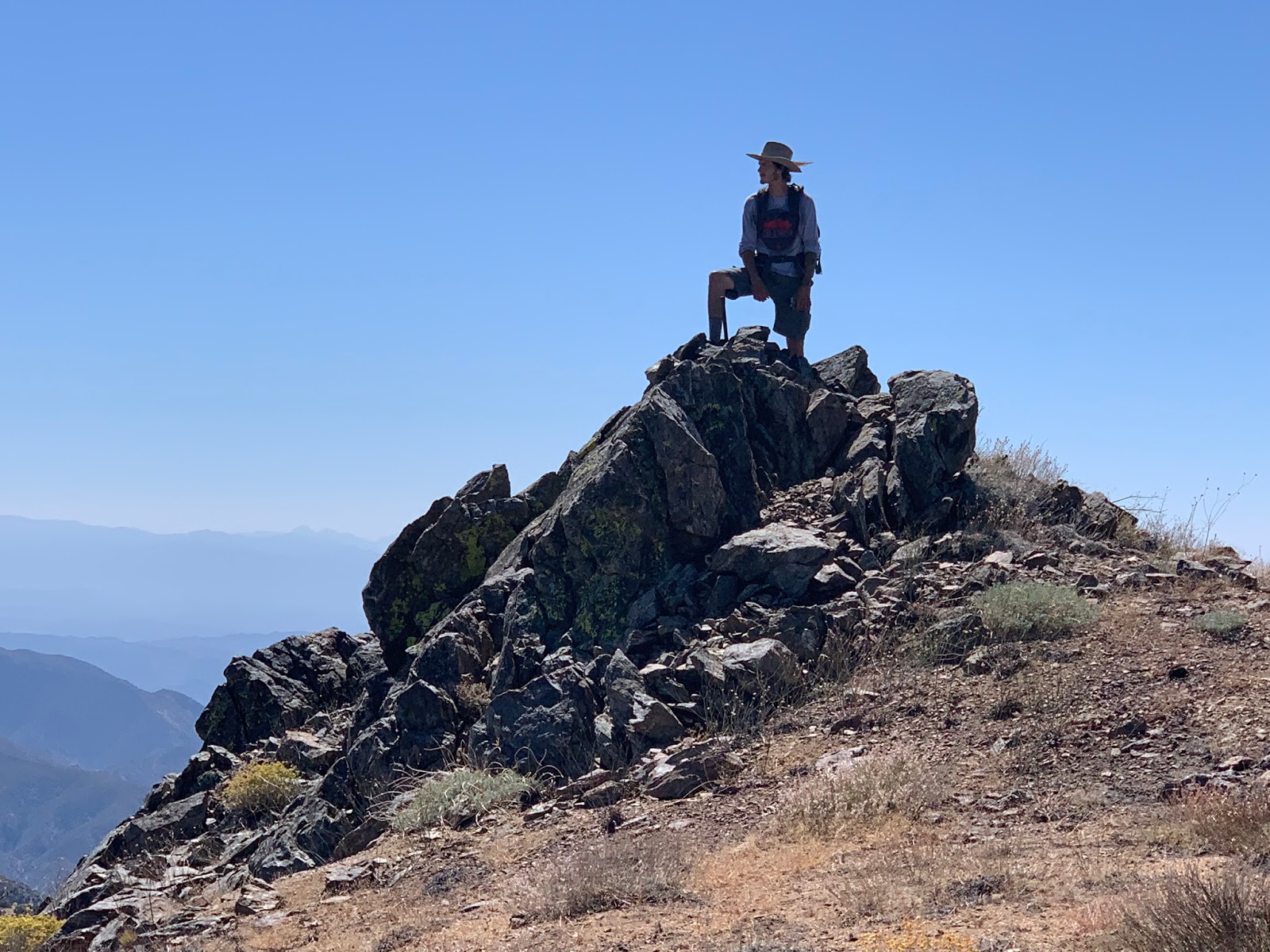
| San Rafael Peak top left corner |
 |
| Last Push to the top |
 |
| HPS Register Can |
Once at the top in the large rock pile one finds the HPS can register with signatures dating back to 1974. I expected the views from the peak to be good, that however is a gross understatement. These may have been some of the best I have seen in the Los Padres. Absolutely phenomenal. With I think my favorite being the perspective gained on the Topa Ridge.
 |
| Looking east toward Cobblestone Mountain |
 |
| View North with Mcdonald peak far right corner |
 |
| Topatopa and Devil's Heart |
 |
| Southwest view Hines Peak centerstage |
From the car to the Summit was about 5.6 miles and it took us around 2 hours and 45 minutes. An out and back from here would make for a good 11 mile day, but we were not finished. Our next order of business was to descend the ridge down the North slope for a touch over a mile and back onto the Little Mutau Trail much further along than where we initially left it. Again as before more use and game trails can be followed down the ridge and this area is much more open than the lower chaparral zones making navigation a whole lot easier.
 |
| Making our way down the North slope of San Raf |
 |
| A look back at our exit point from San Raf and back onto 20W10 |
 |
| Guerrilla site approximately .4 of a mile downstream from Little mutau Camp |
It seems that several Maps have the location of Little Mutau Camp wrong, (this is not surprising). Citing one example if we were diligently following the Los Padres National Geographic Map it would appear that upon reaching the creek we would have made a right onto Little Mutau 20W10 and within approximately .2 miles been to the Camp. There is a nice sized grassy flat at this location but that's about it. The actual camp is about .6 of a mile further up the trail. Makes you wonder how many folks made it all that way to perhaps think the camp was gone and turn around? See photo below, blue dot is the actual camp location. Also California Trail Map has the location wrong, guess I should email Lee and let him know. Update I Spoke with Lee after my initial write up and
California Trail Map will have this fixed on the next update. Unfortunately it also appears our friends over at
Hike Los Padres have the location incorrect as well. This is a common theme that drives me nuts, one mapping error can have a domino effect as the later maps follow. I know field conditions can change and this may sound a bit harsh but I'm still of the opinion if you can't field test your maps don't put them out.
 |
| National Geographic Map showing Little Mutau Camp in the wrong location |
 |
| This tree fell in the perfect spot, provided a nice bypass to a very brushy section of trail |
Little Mutau is a small primitive Camp situated right off the trail on the north side of the Creek. There is one steel cooking grate, rock fire ring and ice can stove. The Flat is rather small but you could possibly squeeze 2 tents in there. Water was dry from the creek directly adjacent to camp however could be readily obtained about 450 feet further up the trail. There is another flat closer to where the water is that could be used as an overflow or to help accommodate a group. There is no shade directly over the site but a nice tree about 50 feet away along the trail provides a good amount to relax or eat under. Camp Coordinates
N34° 38' 06.2" W118° 59' 28.6"
 |
| Little Mutau Trail Camp |
 |
| Another view showing the Flat |
 |
| Shady spot adjacent the Camp |
 |
| Water flowing east of Camp |
After completing the survey and some sprucing up of the Camp we were off. Earlier immediately upon dropping down from the peak I noticed the temps had increased quite a bit and by late afternoon it was getting downright hot. Not unmanageable hot but we still had about 5 miles left back down Little Mutau trail before reaching the car at Johnston Ridge TH and while technically you are travelling downstream the trail eventually leads you up and out of the creek bed for one last additional good climb to meet back up at where we first exited it for the Peak, after that it is all mostly downhill and smooth sailing. Our total mileage for the day was around 14 and that does not include a few extra recon side trips we took while in the area. All the climbing combined with the long miles and warm weather I was definitely ready to get off my feet and pop a cold one. I have included a map below with our route and all relevant waypoints and the option to download my GPX track and KMZ File.