|
| The Pothole and Devils Potrero pictured above |
The Devils Potrero Loop can begin at the Potholes Trailhead (18W04) or the Agua Blanca Trailhead (19W10). Access to these Trailheads can be a bit of a pain in the ass as both are situated along the now closed Piru Canyon Rd (4N13). The closing of Blue Point Campground in 1999 to protect habitat for the Arroyo toad pushed Potholes Trailhead access back 2.8 miles to the Gate at the Juan Fernandez boat launch at Lake Piru. To further complicate things extreme low water in the lake has closed this boat launch and pushed access back another 1.5 miles to the Visitors Parking area Adjacent to Reasoner Cyn. So plan on about 4.5 extra miles to the Potholes Trailhead and around 7 extra miles if your starting on The Agua Blanca Trailhead at Kesters Cabin.
 |
| Lake Piru Guard Shack |
 |
| Deer at Temescal Station |
Day use parking at Lake Piru is 10 Bucks. If no one is at the guard shack in the morning you can fill out the slip and pay the iron ranger. Temescal Forest Service Station is also here just west of the guard shack, almost always you will be greeted by the family of resident Deer that hang out here at the station. Once through the main gate drive all the way back to the visitors parking area pictured below.
 |
| Parking area Coordinates N34° 28' 48.3" W118° 46' 14.5" |
To get this loop done in a day without making it tougher than it already is I recommend bringing your bicycles. We rode our mountain bikes from here 4.5 miles along the paved road and stashed them in the bushes at the Potholes Trailhead. There are great views along this stretch of road of the Piru Canyon drainage, Lake Piru and its surrounding peaks. Immediately after getting out of the truck we were greeted by a small family of Coyotes who howled at us for a couple minutes. In less than a mile down the road we also saw another large family of deer and the resident cows.


One of the advantages to the access issue here is the area sees little traffic which gives it that wild and remote feel. Besides a few volunteers who help maintain the trail this area is mostly ignored and forgotten by most hikers. Fun Facts there was once more to this area than meets the eye. You may have noted just before you reached the parking area a locked gate on your left to Dominguez Canyon. Before the private property closing, Road (5N02) lead you to Dominguez Campground and further to Rodeo Springs Trail (18W08). Both of which have fallen from current maps. Also the mouth of Reasoner Canyon west of the parking area was the Starting point for Forest route (18W07) as pictured below from the 1967 LPNF Map. I do plan on further exploration of these decades old routes.
 |
| 1967 LPNF Map showing Rodeo Springs and Reasoner Canyon Trails. |
 |
| Piru Creek Drainage & Whitaker Peak looming in the distance |
At about 4.1 miles in along the paved road there is a small spur trail that leads you down to the memorial of Juan Fustero. Born on the Temescal Ranch in 1841 Juan was the last Full blooded Tataviam male of the Piru Indians.
 |
| Juan Fustero memorial plaque |
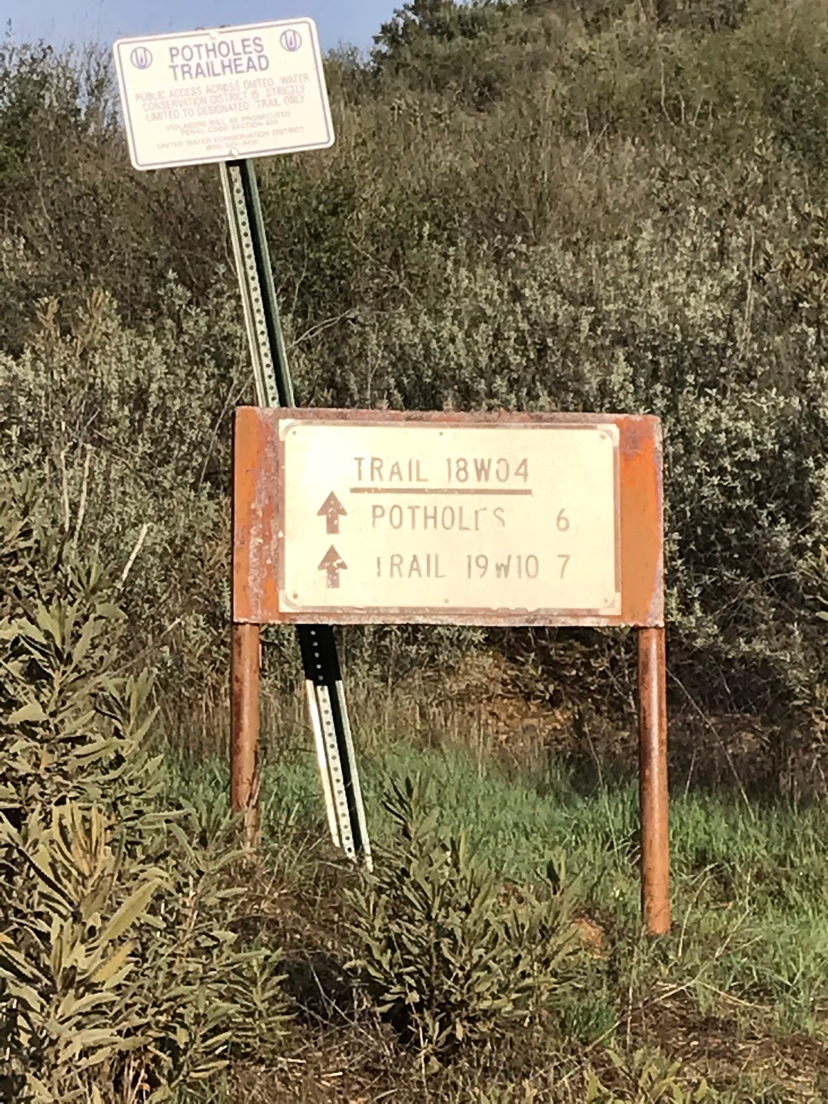
Back on the road and in about .4 miles from the memorial Plaque you will arrive at the Potholes Trailhead. Just after the bend in the road keep an eye to your left for the Trailhead Sign.
 |
| Potholes Trailhead Junction sign |
 |
| Jeff heading up through the meadow |
From here and for the next 2.5 miles it is a beast of a grind up though the grassy meadow to the top of the ridge. You will gain a little over 2100 feet of elevation. For not getting much use the Potholes trail is well defined and easy to follow all the way to its northern terminus with the Agua Blanca Trail. This stretch toward the ridge has outstanding views of both the Agua Blanca drainage and the Piru Creek Drainage. Blue Point, Cobblestone and Whitaker peaks also dominate the scene. In the summer this trail is hot, exposed and most likely tick ridden through the lower meadow reaches. Right now we had none of that. This makes for a fantastic winter hiking spot. The current rains also brought out a whole host of different mushrooms, most variety I have seen at one time. Some edible, others not so much. Jeff snacked on a few along the way. DON'T EAT WILD MUSHROOMS unless you're absolutely positive of the variety. Eating the wrong mushroom will KILL YOU. I will refrain from posting any mushroom pics so as nobody accidentally eats the wrong one.
 |
| Views toward the Agua Blanca |
At the top of the ridge and about the 7 mile mark is the Potholes Sespe Wilderness Boundary sign. Here the trail turns North and you begin the descent down toward the pothole and the devils Potrero. Unfortunately all that elevation gained is given right back.
 |
| The Pothole |
 |
| Another view of the Pothole |
The Pothole is a unique geological depression from an ancient landslide caused by shifting underground faults. Cottonwood groves have taken up residence here, along with many weeds and brush. The Devils Potrero is the grassy meadow northwest of the Pothole. The trail winds down toward the pothole and eventually through the Devils Potrero. If you want to visit the pothole you will need to exit the main trail.
 |
| Devils Potrero |
After you have had your fill exploring the area around the Pothole and the Potrero keep heading north on Potholes trail. In a very short distance your will see a very old rusted no trespassing sign and what remains of a barbed wire fence.
 |
| No Trespassing sign |
At the 9.4 mile mark and my favorite part of this hike you arrive at the Whitaker Cabin Site and the unofficial Pothole Spring Camp. In the late 1800's William Whitaker purchased 80 acres of land and built his small farming cabin here adjacent to the spring.
Old farming equipment lies strewn about the landscape, all of which was dragged up here by mule. The cabin is still standing, though not in the worlds best condition. There are 2 rock fire pits and the area is completely shaded by large Oak trees. The spring had water flowing as did the adjacent creek leading down to the Agua Blanca. I absolutely love exploring these historical sites. With this particular one being only 1 mile from the Agua Blanca junction I would much rather prefer to stay the night here as opposed to the little more frequented Log Cabin Camp. Included below are a few shots of the inside of the cabin. The site is most likely still in the hands of private property, if you pay a visit here please be nice.


Originally the plan was gonna be to get to Log Cabin Camp survey it and return the way we came. However we decided instead to exit down the Agua Blanca and complete the loop. Jeff had not been through the area yet so I was happy to give him the tour. Water is really flowing through Agua Blanca Creek right now. I knew I would be getting wet but did not expect to be waist deep at the lower road crossings with the Piru Junction. Keep that in mind if your heading up.
 |
| Agua Blanca Is a flowing |
 |
| Junction with Potholes and Agua Blanca Trail |
As mentioned above after leaving the cabin it's about a mile to The forest service Log Cabin camp. You will cross Agua Blanca Creek and hang a left at the junction sign pictured above onto Agua Blanca Trail (19W10). Continue a short distance further and you come to another sign signifying Log Cabin Camp in 200 yards. (pictured below).You might notice the odd position of this sign as it appears on your right side and facing toward the mountain side. The reason for this I believe is the original Agua Blanca trail directed you up and over the hill so as to bypass walking through the devils gateway just below. Currently that section is washed out and no longer maintained so its standard practice now to just chug along through the Creek.

Log Cabin Camp is the first designated Forest Service Trail Camp you will find coming up from the Agua Blanca. Originally 4 sites, BBQ stoves, rock fire pits and Ice can stoves are available for use. The area is large and will accommodate a good amount of tents. As far as privacy is concerned it is probably best used as 3 sites now. With the first site being the nicest. Oaks provide plenty of shade and water is readily available from the creek. As the name would suggest there was once a Cabin here now long gone. I included a few shots below of the Camps site amenities. To my surprise on this day we did find some campers here.
 |
| Log Cabin Camp site #1 |
 |
| Log Cabin site #2 |
 |
| Log Cabin site #3 |
After leaving Camp we headed back past the potholes junction making our way through the devils gateway and down the Canyon. The trail is in pretty good shape and mostly easy to follow. The hardest parts are some of the creek crossing where you may lose the trail. Look for flagging in the trees marking the crossing points. With a little keen observation you will always find the trail to pick up again. I noted only 2 downed trees across the trail below Log Cabin Camp.
 |
| Devil's Gateway |
The Agua Blanca Canyon is one of the most scenic places in the Ojai Ranger district. A truly wild and remote experience. This section of the forest never gets old to me. I tried vigorously in the beginning every trick in the book to not get my boots wet and was successful for a time being but that eventually ended with a slip into knee deep water. So yeah wet boots it was for the remainder of the trip.
 |
| Me trying hard at first not to get wet |
At the 12.6 mile mark we came upon the Agua Blanca Sespe wilderness sign. This sign has a special place in my heart as I helped install a new 4x4 post on it some time ago. Glad to see it was still in good shape. Even complete with new bear claw mark.
 |
| Agua Blanca Sespe Wilderness Sign |
 |
| Kesters Cabin |
From the Wilderness sign it's just over a mile to Kesters cabin. You will need to pass straight through the middle of this private property. Here roughly marks the lower Agua Blanca Trailhead. After the Cabin follow the dirt road around the bend and south to Whitaker Ranch. (Joe Ritchey's Cabin). Right now the multiple road crossings before reaching Blue Point are raging . We had swift moving waist high water. Use extreme caution when crossing these spots.
 |
| Whitaker Ranch |
 |
| Jeff Navigating the easiest of the crossings |
Heading toward Blue point the area has some really nice wind eroded caves to explore. Stumbled upon a geocache below one of the openings. Passing Blue point I noticed the picnic table and restroom site along the road is now gone. Looks like some decommissioning has taken place since I last went through. Back on the paved road it's only another 1.5 miles to the Potholes Trailhead and where we left our bikes to complete the loop.
 |
| Wind Caves North of Blue Point can you spot the geocache ? |
 |
| Not much left of Blue Point Campground along the road |
To recap this was a long day but a good one. My heart has been here in the Piru Backcountry ever since I through Hiked the Creek a few years back. Its Peaceful, remote and beautiful country. Don't let the lack of access prevent you from visiting the area. Total mileage for the day was just under 22. With 9 miles on the bikes and about 13 on foot. I hear whispers that eventually they will be opening up the road to Potholes Trailhead. I do hope this comes to be. GPS Track and KMZ file included for download under the map.