Sunday, November 26, 2023

38 Special Series - Lost Knife Camp (M46)


Lost Knife Camp

So, it has been some time since my last post. I recently underwent a radical life change, started a new career in the commercial fire alarm industry and moved up to Northern California. Currently you can find me living in San Ramon under the shadow of Mount Diablo. Do I miss the LP? Tremendously I do. Not a day goes by without thought of it. Miss my few good pals? Indeed with everything I got. Will I return? Absolutely I will, as soon as I can make it happen. I needed out of Hollywood and La County. My job was forever stuck there. If I was to ever leave I would need a new career, so after years of discussion with my brother who is in the Fire life safety industry I finally made the jump. As I figure it I am up here training, learning the ropes. The company I work for was flirting with the notion of maybe opening an office in San Luis Obispo. At least that is what I was told before I committed to going up. If it happens you can bet I'll be the first to go. Anyhow that's my update for now, sorry for the long absence between posts. Now to Lost Knife.


1938 LPNF Recreation Map showing Lost Knife (M46)

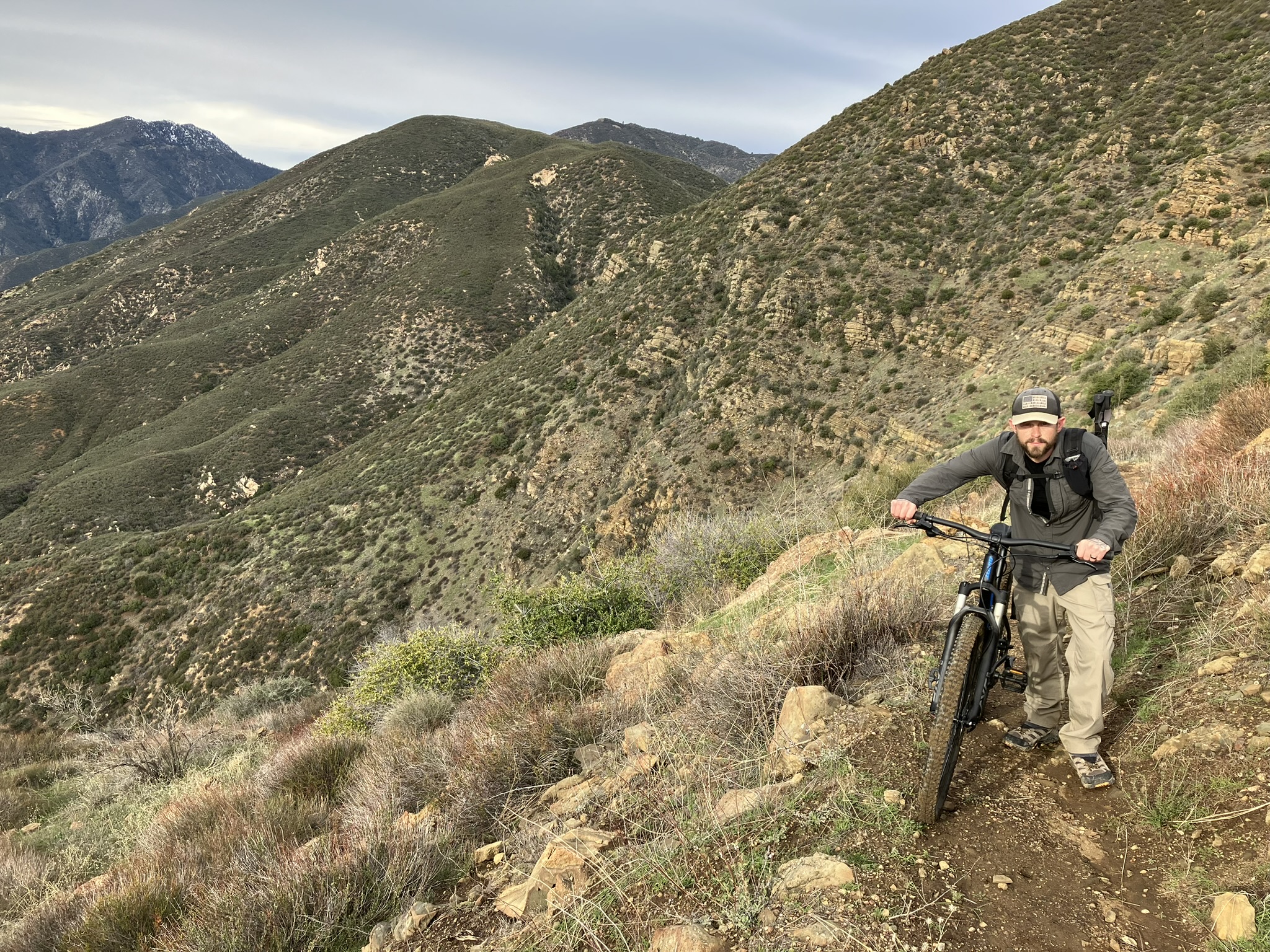
Drop in point from Sierra Madre Ridge.

It's no secret my admiration for the 38 map. Hell I love the damn thing. So many obscure camps made a single appearance on it, never to be seen again on newer additions. The idea of locating them just always excites me to no end. What I thought would be neat is to put out posts highlighting the ones we can find. I'm calling it the 38 special series. Unlike past write ups with my endless babble the pictures will tell the majority of the story for these. No step by step directions here, occasionally during a more amiable moment I may provide GPS coordinates. Generally these sites will be very remote and not something most will want to try for anyhow. The hardy ones that do will figure it out with the photo clues. If you have a copy of this map and want to collaborate on future missions I'm all ears, just shoot me a message or leave a comment on the post. 

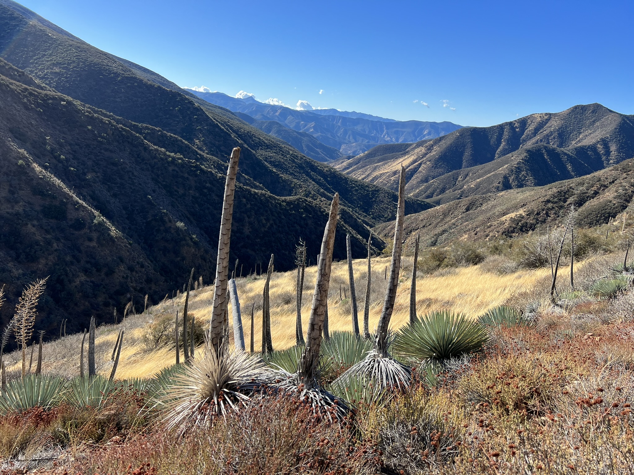
Target drainage in the distance

Beautiful meadow midway down


Yucca in these parts be relentless, no one came out unscathed. Yo Nate how's your ass cheeks feeling?


At Lost knife we found a single Ice Can stove, tipped sideways, atop an old axe and covered in brush. The photos below show the exact location and the surrounding area. Where the stove was found did not seem like the ideal spot considering there was a much nicer flat just before it and another across the creek where the fire ring with old cans was observed. Perhaps at some point it was moved or maybe in the past there was multiple camp sites and this Ice Can is the sole survivor. Without a site record one can only speculate. Regardless it was a lovely spot and we look forward to returning when we go after Blanco (M45), Cone Spring (M44) and Live Oak Spring (M28). 


Larger flat just across the creek.


Admittedly we did get a late start and could have done a much better job searching the vicinity for more clues. I can all but guarantee we missed a few relics. Unfortunately "daylight wasting time" (stole that phrase from Flemming). Did not afford us the opportunity to loiter for vey long. Nevertheless this was a win, and hell of a good trip. Felt great to be back in the forest I adore so much with my pals. 


If you enjoyed this post you can use the feature below to subscribe by email and receive additional posts delivered to your inbox as I complete them. If you don't want to follow by email there is also the option to subscribe via the RSS feed reader widget. Which you can access from the desktop view.  Thanks for the support.  

Subscribe

* indicates required

Intuit Mailchimp


Saturday, February 25, 2023

Thoughts on the Los Padres National Forest Closure (Storm Damage January 2023)


Upper North Fork Matilija. Slide on the high side east bank. 

Regarding the recent closure I have been silent thus far. These days working as a USFS Volunteer with The Partners In Preservation I thought it best not to inject my personal opinion into such contentious matters. I still stand by that. Plus what's done is done, as they say no use in crying over spilt milk. While I have been able to get into the field during the closure doing official site assessments I like most all of you, don't enjoy the current situation, and look to propose future solutions. 

Refugio Road, photo credit: Curt Cragg

Here's what what we do know. The United States Forest Service is both understaffed, and underfunded. It's been this way for years. The way I understand it and correct me if I'm wrong here, is plenty of money becomes available during/after a wildfire but for natural disasters such as this that's not the case. So in such instances where residents were left stranded, cut off from food, basic essentials, medications, roads completely destroyed, trails unrecognizable, all out wide spread forest destruction. It is not inconceivable to imagine perhaps panic sets in on a department that is overwhelmed and lacking the resources they so desperately need.  All that said was this broad shutdown justified and should these continue to be something the public comes to expect? On the latter I for one hope not. We can do better. 

Mono Campground, photo credit: Los Padres Forest Association.

One thing FS doesn't lack is volunteers. Free labor, why not lean more on us in these situations? We are here, always standing by and ready for deployment. Yes they already utilize volunteers but in my opinion not enough. I am proposing each ranger district assign specific trails/roads to their volunteers who can then after a crisis immediately assess the damages and in real time report back on what should or should not be closed. You wont need a broad forest closure if you have hundreds of volunteers all ready and trained to descend upon their pre assigned locations after these types of events. Of course with that comes following proper check in and check out procedures with LP communications, and adhering to safety protocols, perhaps even requiring teams carry satellite communicator's in the field. Instead of a handful of the same people spread out over months assessing individual locations we launch a full scale volunteer assault within the first week, put eyes on the entire forest and use pinpoint precision to close what needs closing, while leaving the rest open for public enjoyment. Those not doing field surveys can help by posting signs at all the trailheads warning of possible dangers. This is obviously a over simplified explanation. A program like this will take thought and preparation so might as well get started on it, or something like it. 

Grade Valley,  photo credit: Craig Carey & T111

Imagine the pride and satisfaction both the people and the administrators can have knowing they can work together in times of crisis for the greater good of the community and the forest. Trust restored, problem solved. I don't want to hear it cant be done, because it can. You don't need money to train volunteers when you can use other volunteers to do it. I will be the first to raise my hand to help anyone that wants to participate and learn how to properly survey a trail. And I'm not alone, countless others would do the same. Do the hard stuff, prepare ahead of time. A good solution is often not an easy one. I urge the Forest Service to consider expanding the duties of its volunteers. Lean on the established trail organizations and individuals who have proven themselves in the field. We want to help, please let us do more. The Los Padres could if there was a will and under the right leadership Pioneer a world class volunteer program, that becomes the gold standard across all forests.


Hwy 33, photo credit: Caltransdistrict7

If you enjoyed this post you can use the feature below to subscribe by email and receive additional posts delivered to your inbox as I complete them. If you don't want to follow by email there is also the option to subscribe via the RSS feed reader widget. Which you can access from the desktop view.  Thanks for the support.  

Subscribe

* indicates required

Sunday, January 8, 2023

Bailey Trail recon via Slide Mountain


Historic Bailey Homestead as seen from afar (center disturbed area beyond the ridge)

As far east as one can venture into the Los Padres (Sespe Wilderness) on the border with the Angeles National Forest is the seldom used Bailey Trail 18W02. According to former maps along this path approximately here N34° 38.912' W118° 48.200'  was the historic Bailey homestead site. Since the closure of Hardluck Campground this area has been notoriously hard to access and as such the trail gets almost zero use and has fallen into complete disarray. Historically 18W02 ran southeast from the junction with Buck Creek Trail past the homestead, down Beartrap Canyon and terminated at Lake Pyramid. I'm guessing actually at the time perhaps Piru Creek before the lake was installed. Another prominent feature at this terminus was what Lopez described as Bridgeport Flats #4. "A high terrace on the west side of Beartrap Canyon Creek where it flows into Piru Creek. 16 bedrock mortars" I feel comfortable disclosing this as I'm certain the feature now lies forever hidden under the lake. Perhaps time to dust off the old scuba gear.  Bailey has been on my mind for several years, why it has taken me this long to begin recon I don't know, but better late than never.

Frenchman's Flat

Slide Mountain Trail 18W04

I don't have an FS gate key and I despise the road walk to Hardluck, so much in fact I vowed not to do it anymore. I've done it on a bike and on foot, it's a pain in the ass. So with that said I decided to give it a go from Frenchman's Flat. Spoiler alert we did not quite make it to the old homestead nor the terminus of 18W02 At Pyramid. We were very close but no cigar. No matter though we gathered excellent intel for the second attempt and there will indeed be one. Perhaps I can beg a kind sole who has access to drop me at Hardluck. 


Jeff and I rode the 1.75 miles along the paved road from Frenchman's Flat (2095') to the Slide Mountain gate then proceeded to push our bikes the next 3.75 miles up to the Slide Mountain Lookout (4631'). After a brief visit we locked our bikes and set off afoot down the northwest ridge dropping approximately 1700 feet in elevation into Beartrap Canyon. The switchbacks leading down that once was is no longer. Forget about even attempting to try following that old trail. While we pushed through brush the entire time down the ridge it wasn't terrible. Being non old growth and mostly Chamise it's actually quite forgivable. 


 Looking back toward Slide Mountain

Surprising small flow in Beartrap Canyon


As you can see from the map above the old cut in red that once connected with the Bailey Trail took you about 0.3 of a mile downstream from where we dropped in after which gaining the western bank and bringing you right back,  just much higher up. We made the mistake of trying to follow this. In hindsight we should of just tried to climb it from there and push on toward the homestead but it looked steep and impenetrable. So with that we continued on downstream. All things considered we were moving along pretty good at first but just under a half mile to the lake progress came to a grinding halt. The canyon is chock-full of deadfall and poison oak. You know that couple hundred feet in an hour kind of pace. We didn't have the daylight for that. The realization quickly set in that we were not getting to the homestead nor the waters edge. Neither one of us had any interest in riding back down Slide Mountain in the dark. After acknowledging defeat we sat for a bite to eat adjacent the god awful black tubing that runs from the spring toward the lake. Yet another Beartrap littered with this shit. 

So close but yet so far.

And that's about where our day ended - N34° 38.872' W118° 47.301'

Pot Grow - N34° 38.816' W118° 47.319'

The Climb out.

Total mileage was around 15 but felt like twice that. My legs were torched from what was essentially climbing Slide Mountain two times in a day. For a novice mountain biker I will say that ride down was thrilling and totally worth dragging the bikes to the top. 


If you enjoyed this post you can use the feature below to subscribe by email and receive additional posts delivered to your inbox as I complete them. If you don't want to follow by email there is also the option to subscribe via the RSS feed reader widget. Which you can access from the desktop view.  Thanks for the support.  

Subscribe

* indicates required