Friday, June 22, 2018

Big Tujunga Cyn Reservoir and Josephine Falls


In need of some new local fishing spots, back in April  I went  on a quick scouting mission to find an easy way to access Big Tujunga Cyn Reservoir. From satellite maps I was able to spot what looked like a spur trail leading down to the reservoir from Big Tujunga Cyn Road. This was enough to warrant further investigation. So joined with my pal Dan Thompson we went and checked it out here's what we found. The trail does exist and is pretty good shape aside from the last 100 feet that drops you onto the canyon floor. That section is washed out with a lot of loose rock. It's definitely doable but would be a little sketchy if you had full Packs and or just camping gear for an overnight. 

Reservoir is around this bend to the left.
Once you reach the canyon Bottom the trail disappears and you will want to follow the river channel west to the mouth of the reservoir. A very short stretch around .2 miles will require bushwhacking. We found it easiest to just walk through the creek here to avoid some of the more heavy brush sections. Once past this, the area opens up very wide and travel is a breeze to reach the Reservoir. There is plenty of spots nearby by to camp for the night if you choose to. (I would check with the ranger station first to find out if camping is even permitted here ) I didn't see anything in Fish and Game regulations about no fishing in the reservoir so I'm assuming its fair game but don't quote me on that. Again probably better to call first beforehand. Once we reached the water I walked in quite a ways to check it out. The beginning is very shallow marsh land. Without the risk of getting myself in a any trouble I will go as far to say that most likely I had my pole with me :) as I usually do. Never leave home without it.

Can you spot me in the distance
The added bonus to this little adventure was we discovered a waterfall that we were not expecting to find. 0.6 miles down the Trail there is a junction for another very short trail leading to the base of Josephine Falls. (170 foot Drop) I was told this is a great spot for those who like to rappel. This is a nice shady little place to have some lunch and relax by the creek during the midday's heat. It now makes sense that the trail was in as good as shape as it was due to the waterfall being here.


4 miles was our total for the day out and back. If you just wanted to hit the falls and leave it would be even less. Another successful mission and good times exploring the Angeles National forest. Should you decide to visit there is a parking turnout located right off Big Tujunga Canyon road. The spur trail is right next to the turnout. To be safe display your adventure Pass. Click the link to view in google maps. Park Here


GPX File Download (GPS Units)
KMZ File Download (Google Earth)

Monday, June 11, 2018

Piedra Blanca Trail from Reyes Creek Campground


Bored one weekend Dan Thompson and I decided to take a road trip to the Reyes Creek area. If you have not visited this place I highly recommend you do so. The Reyes ridge along the backside of Pine Mountain has some of the best scenery in my opinion that the Southern Los Padres Has to offer. Loaded with a rich mix of confers, oaks, pines, alders and cottonwood it really is a site to behold. This adventure started as mostly a scouting trip of the Reyes Creek Campground to see if it would be a nice place to take the family sometime and the stream that runs through it I heard might have some fish in it.  Always looking for a place to cast my line in the water I heard this stream was stocked with trout during spring when water levels are high enough to support them. So naturally of course I had to see for myself. Located at 26901 Camp Scheideck Rd, Maricopa, CA 93252 off Highway 33 and Lockwood Valley Rd, this 26 site camp offers creekside spots shaded by oaks and cottonwoods. Right before the Campground is the small community of Camp Scheideck. This was the homestead of Eugene Scheideck founded in 1988 the property now hosts The Reyes creek bar and grill (awesome to be able to get a good burger and beer after a long day of hiking and or camping). You also find below the camp some kind of small Ghost town. I'm not exactly sure of the history of this place but it was sure neat to stumble upon it. I had no clue it was there. All and all I was impressed with everything this little campground had to offer. Hiking, camping, fishing, a bar and grill and ghost town no doubt enough action to keep the family entertained. I will for sure be returning with the wife and kids sometime for a weekend excursion here. This place is run by parks management for  the forest service so Adventure passes are no longer required. Camping is 20 dollars per night and 10 dollars per vehicle for day use.77% of the sites are on a reservation system, 23% are available first come first served basis. For more info or to book a spot visit https://www.recreation.gov/.


After visiting Reyes Creek Camp we took off on the Gene Marshall-Piedra Blanca Trail, which is located on the west side of the campground along the paved road just over a small rise. There is ample parking here and a toilet. The first couple miles of trail climbs out of the canyon ascending an unnamed drainage through oak and chaparral to the top of a saddle. Through this stretch of wilderness you are afforded stunning views of Pine mountain and the chance to look back down the canyon and gaze upon the hills of the Cuyama Badlands.


Descending from the saddle  at about  the 3 mile mark you reach Reyes Creek and  Upper Reyes Trail Camp. Water flow here is mostly year around at this 2 camp site. There are a couple stoves and an immense amount of shade from the surrounding Cedar and oak forest. Situated at an elevation of 4624 ft. This was a very nice spot for us to take a break and then do a little exploring.


From here the trail ascends again  southeast  another 1.5 miles to a saddle before descending down to Beartrap camp at about the 5 mile mark. This stretch of the trip was by far my favorite as far as scenery is concerned. Thick confir, cedar and alder forest make you feel like you've been transported to another realm. The creek here usually flows year around and Beartrap sits at about 5100 ft elevation mark and has access to 5 camp stoves. Not only are the views here amazing but the camp has some interesting yet at the same time sad bit of history. Beartrap got its name from the grizzly bears that used to roam this area. Reports say the Reyes family used this camp to trap them back in the 1800's. At that time many thousands of grizzlies made there home in the backcountry of California. Hunting decimated this poor species and its said that the last remaining grizzly bear was shot in 1922 at a ranch in Tulare County. :( 


Because we got a late start on this day Beartrap was our turn around point for this trip. However you can continue on Piedra Blanca trail if you want all the way to the Sespe River. The next campsite about 3.5 miles further you would come to is Haddock camp at 6100 ft elevation. This site has 4 stoves and  good seasonal water, mostly reliable in the summer months.100 percent I will be returning to complete the trail from Reyes Creek Camp down to the Sespe. This place is absolutely magical and definitely warrants a visit if you have the time. 10 miles was our total mileage for the day out and back. A nice stroll it was.


Download GPX File (For GPS Units)
Download KMZ File (For Google Earth)

Tuesday, June 5, 2018

Hard Luck Camp and upper Piru Creek


This mission had two objectives. First one being to complete the Second leg of the Piru Creek Project. I've now seen everything the Creek has to offer from Lake Piru to Above Lake Pyramid and ending just passed the old now closed Hard Luck Campground. Second objective bring Tony Marchese back to Hard Luck where he has so many great memories camping and hunting with his Dad. Logistically this is not the easiest site to access. Established in 1961 Hard Luck Camp and the road leading into it was permanently closed and no longer maintained in the summer of 2009, due to it's close proximity to Piru Creek which provides habitat for the endangered Arroyo Toad. This once 26 car site Camp served as the starting point for Buck Creek Trail(18w01) and Upper Piru creek. You basically have two options now. Hike in from the west via Alamo Mtn(8n01) and Stewart Mtn (6n10) Route, or From the East Gate near Los Alamos Fire Station along the 3 mile now closed Hard Luck road. We chose the latter. Remembering our past mistakes from Lower Piru and hiking in on long, hot, and boring paved roads and how much it sucked. We decided this time to add mountain bikes to this section of our itinerary. Tony picked me up at my house early the morning of and we loaded our packs and mountain bikes in the car for the drive up to Los Alamos Campground where we would leave the car parked overnight.


The weather that weekend was forecast to be hot so in order to stay cool we outfitted the bike I would be riding with saddle bags in order to carry our Ice Mule coolers loaded with beers :) After finding a nice place to park for the night we paid the fees and off we went. From the campground parking lot it was only about .7 miles to the locked gate


From here the next 3.5 miles uphill and then downhill to Hard Luck is rather grueling, especially on a bike carrying a heavy pack. Granted it was still much nicer than walking. I did take note of how bad it would be on the way out from the treacherously steep hill we just went down. Coming into Hard Luck we crossed Piru Creek which still had a decent flow of water for being so late in June. We spent a little time investigating what was left of Hard Luck and Tony Got to relive those old cherished memories with his pops from all those years ago.


We continued our ride along the trail as long as we could before it was no longer passable on a bike. Eventually we found a nice spot to stash the bikes. After a quick break we locked them to a tree and off we went on foot. 

Leaving Hard Luck your awarded with some really nice views of the surrounding valley and  mountain ranges. While here I did do some fishing in the upper creek, I didn't catch anything this time around but I really wasn't trying very hard either. Upper Piru is a wild trout program and only artificial lures and barbless hooks may be used with a 2 trout possession limit.


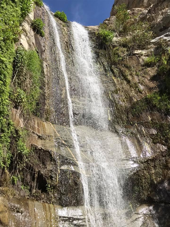
Our original plan was to follow Piru Creek until it ran into Lake Pyramid. Hoping to camp for the night near the Lake. At about 6.5 miles in we came to the junction of Piru and Buck Creek and surprisingly Buck Creek had a decent little flow of clean cool water coming in. Before heading completely off trail and down into the Piru drainage  we did do some exploring up Buck Creek and found some nice good sized pools to soak in. Note the trail from here up Buck Creek is not in very good condition, it appears then disappears in quite a few places. I would imagine it would be quite difficult to make it all the way up to Buck Creek Trail Camp. Lots of Bush whacking and trail searching involved. I'll have to return another time and explore that one further.


Heading Down Piru very close to the Buck creek junction in the middle nowhere comes this man made gaging station. This in stream structure acts as a barrier to upstream fish migration of non native species under most flow conditions. There has in the past however been reports of anglers catching Large Mouth Bass up and around Hard Luck.


The geology here in the Piru canyon is fascinating. Conglomerate rock formations form steep canyon walls, full of holes with nesting birds in them. At the right time of day the canyon provides a good  amount of shade, something we really needed at this point as the June heat was kicking our butts. I spotted a few turtles hanging by the station structure here as well. 


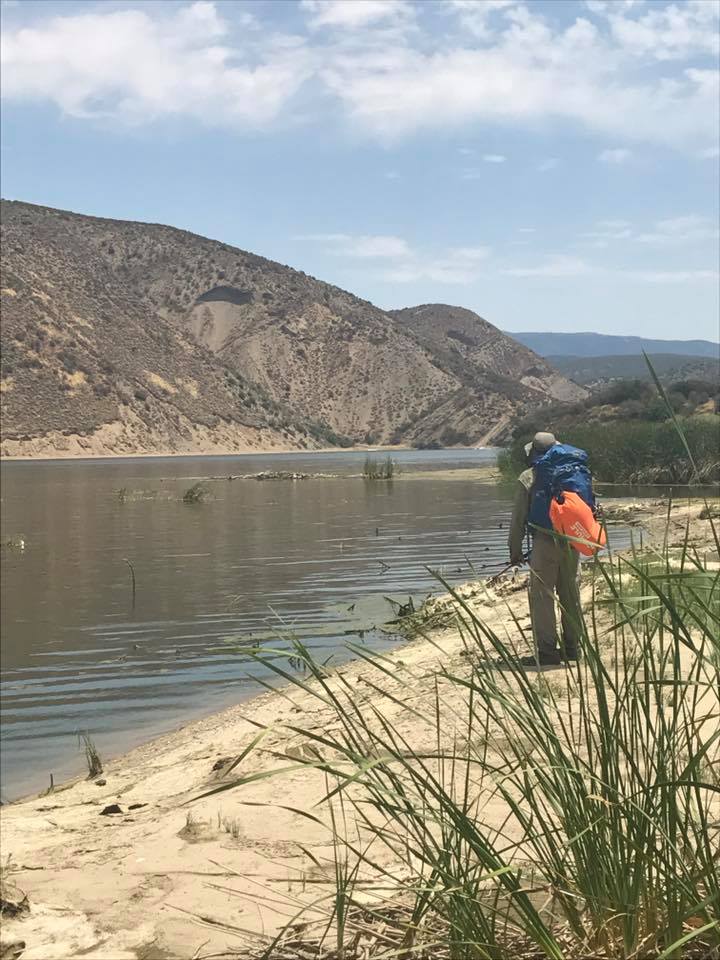
We followed the drainage for approximately 2 more miles before reaching the Lake. Water flow in the creek got lower and lower the closer we got to Pyramid and eventually stopped flowing altogether. About a half mile before landing on lake we got the pleasure of tromping through wet muddy marsh land and to make matters even worse there was no nice dry place to camp and absolutely no shade by the lake. Tony went for a swim and I cracked a cold one and pondered our next move.


At this point we still had plenty of Daylight left so we decided to head back and camp near a spot we noticed by junction with Buck Creek. Our camp had a nice rock wall to sit on and store our gear and good flowing water from Piru. It was actually a really beautiful spot and had a good amount of wildlife around as well.


As I mentioned plenty of times it was Hot, so damn hot I really did not sleep well at all. I was at one point tempted to go lie in the creek during the middle of the night and sleep there but fought back the temptation as that would not be very environmentally stewardedly of me. Eventually it cooled off enough for me to drift off. The next morning we woke, had coffee and breakfast and high tailed it back out the way we came in. Luckily the bikes were still at the stash spot. (not like there is anybody else out here who would have taken them). I stopped a few more times on the way out for a little fishing but again was skunked. Note: the bike ride out is an ass kicker. Basically straight up hill, its slow going and brutal. Once you reach the top of the ridge though its nice and all downhill back to Los Alamos Campground. Besides the heat and ugly bike hills the trip was great I had a blast. There is still a vast upper section of Piru Creek I need to explore before I can say I have travelled the whole length but section 1 and 2 are officially in the books. Our total distance for this trip was about 19.5 miles.


Download GPX File (GPS Units)
Download KMZ File (Google Earth)

Sunday, June 3, 2018

Trail Canyon Falls


If exploring waterfalls are your thing I highly recommend Trail Canyon Falls. This is another fairly easy Family friendly hike that the kids are sure to enjoy. This stunning 30 foot waterfall was definitely my favorite as far as Southern California falls are concerned. This one is best done in spring or after some good winter rains as summer heat can reduce the fall to a trickle or nothing at all. From the Trailhead its only 2 miles to reach the waterfall. Dogs are welcomed but must be leashed.

PARKING:
Located right off Big tujunga Cyn Rd and the turn out for Trail Cyn Rd. Most likely the gate will be locked and you will have to park along the road. (don't block the gate). If the gate is open proceed to drive into the parking area located .4 miles farther in along the dirt road at 19607 N Trail Canyon Rd. Tujunga, Ca. If you have to hike in from the road your total mileage to the falls and back will be around 4.8 miles. Get here early parking can fill up fast, as seen in my photo below. I've heard an adventure pass is no longer needed here but don't quote me on it. You should display one anyways.


TRAILHEAD:
If you parked at the gate follow the semi steep dirt road until the crest of the first hill. Turn right at the junction and proceed down Trail Cyn Rd to the TrailHead. Which is located amongst a cluster of Cabins. There will be a marker sign pointing you in the direction of the Trail. Follow the dirt road along the Cyn wall, you pass a few more cabins and eventually a sign that that reads "Trail not maintained" that's exactly the route you need to follow and don't worry the trail is in good shape. Up ahead you are in store for multiple creek crossing's and broad views of the Canyon and mountains above.


At around 1.2 miles you begin to hike up along the western wall of the canyon. For the kids this section is probably the toughest, yet for sure doable. My 6 year old made it with no problems. At this point there is little protection from the sun as the vegetation is still making its comeback from the 2009 Station Fire which badly burned this area. Keep going in another .5 mile you will get your first look at the falls.


Close to the 2 mile mark is where the adventure really starts. There is a spur trail leading down to the falls. Its steep and somewhat dangerous with some real ugly spots to traverse. I had to basically cary my little one and help the dog down here. However the reward at the bottom was worth the effort. 


Back at the top of the ugly spur trail you can make you way a little further along the main trail and find another path that will lead you down to the top of the falls. This was my favorite view looking down.


At this point is when most turn around and head back to the car. We opted to go a little further but not much. If you have more time you can continue along the trail for  another couple miles to visit the Tom Lucas Trail Camp


Download GPX File (GPS Units)
Download KMZ File (Google Earth)