Historic Bailey Homestead as seen from afar (center disturbed area beyond the ridge)
As far east as one can venture into the Los Padres (Sespe Wilderness) on the border with the Angeles National Forest is the seldom used Bailey Trail 18W02. According to former maps along this path approximately here N34° 38.912' W118° 48.200' was the historic Bailey homestead site. Since the closure of Hardluck Campground this area has been notoriously hard to access and as such the trail gets almost zero use and has fallen into complete disarray. Historically 18W02 ran southeast from the junction with Buck Creek Trail past the homestead, down Beartrap Canyon and terminated at Lake Pyramid. I'm guessing actually at the time perhaps Piru Creek before the lake was installed. Another prominent feature at this terminus was what Lopez described as Bridgeport Flats #4. "A high terrace on the west side of Beartrap Canyon Creek where it flows into Piru Creek. 16 bedrock mortars" I feel comfortable disclosing this as I'm certain the feature now lies forever hidden under the lake. Perhaps time to dust off the old scuba gear. Bailey has been on my mind for several years, why it has taken me this long to begin recon I don't know, but better late than never.

Frenchman's Flat
Slide Mountain Trail 18W04
I don't have an FS gate key and I despise the road walk to Hardluck, so much in fact I vowed not to do it anymore. I've done it on a bike and on foot, it's a pain in the ass. So with that said I decided to give it a go from Frenchman's Flat. Spoiler alert we did not quite make it to the old homestead nor the terminus of 18W02 At Pyramid. We were very close but no cigar. No matter though we gathered excellent intel for the second attempt and there will indeed be one. Perhaps I can beg a kind sole who has access to drop me at Hardluck.


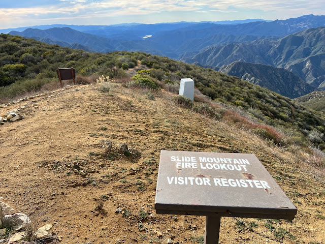
Jeff and I rode the 1.75 miles along the paved road from Frenchman's Flat (2095') to the Slide Mountain gate then proceeded to push our bikes the next 3.75 miles up to the Slide Mountain Lookout (4631'). After a brief visit we locked our bikes and set off afoot down the northwest ridge dropping approximately 1700 feet in elevation into Beartrap Canyon. The switchbacks leading down that once was is no longer. Forget about even attempting to try following that old trail. While we pushed through brush the entire time down the ridge it wasn't terrible. Being non old growth and mostly Chamise it's actually quite forgivable.


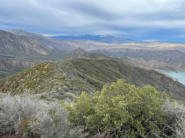
Looking back toward Slide Mountain
Surprising small flow in Beartrap Canyon

As you can see from the map above the old cut in red that once connected with the Bailey Trail took you about 0.3 of a mile downstream from where we dropped in after which gaining the western bank and bringing you right back, just much higher up. We made the mistake of trying to follow this. In hindsight we should of just tried to climb it from there and push on toward the homestead but it looked steep and impenetrable. So with that we continued on downstream. All things considered we were moving along pretty good at first but just under a half mile to the lake progress came to a grinding halt. The canyon is chock-full of deadfall and poison oak. You know that couple hundred feet in an hour kind of pace. We didn't have the daylight for that. The realization quickly set in that we were not getting to the homestead nor the waters edge. Neither one of us had any interest in riding back down Slide Mountain in the dark. After acknowledging defeat we sat for a bite to eat adjacent the god awful black tubing that runs from the spring toward the lake. Yet another Beartrap littered with this shit.
So close but yet so far.
And that's about where our day ended - N34° 38.872' W118° 47.301'
Pot Grow - N34° 38.816' W118° 47.319'
The Climb out.
Total mileage was around 15 but felt like twice that. My legs were torched from what was essentially climbing Slide Mountain two times in a day. For a novice mountain biker I will say that ride down was thrilling and totally worth dragging the bikes to the top.


16 comments:
Oh my God it looks treacherous how in the world did you guys ever make it. Exactly makes you persevere such a task? I congratulate you too but I wish you wouldn't take such dangerous expositions. Great reading but I don't want to visit.
Love ya Gram.
Great review...only been in that area once (November 2014) & also hated that old paved road to & from Hardluck. We got as far back as we could...and it was a grind over tons of fallen trees & brush. We also saw lots of that black tubing...plus bags of rice and beans & trash. We finally camped and then my son climbed Cobblestone the next morning (I deferred after the grueling work the day before-felt I better save my energy just to get back to the car)! It's such a pretty area, though- wish it got more love. Thanks for reminding me about that area!
Love the review. Opens new vistas of understanding of LPNF conditions and Place.
Thanks for sharing your story Ginnie. Happy to hear you enjoyed the write up.
TLC.SLO thanks for the kind words. Appreciate the support..
Always love reading your blog posts, especially like right now when on a business trip, and would much prefer being in the LP than in a hotel room!
Ha Thanks
Ugh, another grow site. How are these guys getting their product out of there? By boat across Pyramid? Certainly not the way you guys came in.
Yep most likely by boat.
Another great post of another epic outing!! Many thanks for all the great work!
Thanks for stopping by. Appreciate it.
There's a bit of a shortcut to Hardluck that makes the hike more interesting.
Hi F, I assume you are referring to the shortcut along the old dirt road alignment.
I actually like the hike down to Hardluck. Unfortunately all my peeps say “one and done” 😞
Love reading your posts. It’s been a quiet year.
Cahikerchick agreed it has been quiet a year. Thanks for stopping by, appreciate the support.
Post a Comment