Sunday, February 17, 2019

Knapp Ranch Via Old Ridge Route

Looking up Cienaga Canyon toward Knapp Ranch

While I am glad we are currently getting a much needed nice wet winter the current snow and rain situation has been making it more difficult for me to visit my usual Los Padres stomping grounds. In thinking of places I could visit a bit closer to home  I remembered Back in July of 2018 I attempted a run up Cienaga Cyn From Templin Hwy. For  reasons beyond my control I did not make it near as far up the Canyon as I would have liked. I vowed to go back and today felt like a good time to do that. This time however would be from the top off Old Ridge Route heading to Knapp Ranch formerly known as Kelly Ranch and possibly even earlier being the physical site of the Pre-1811 Tataviam village of Cuecchao. Inhabited by the Chumash Indian sub-tribe Tataviam, or Alliklik as they were called by locals. (See photo below for supporting evidence).

Found this stone along with others on the Knapp Ranch property about in the middle of all the structures

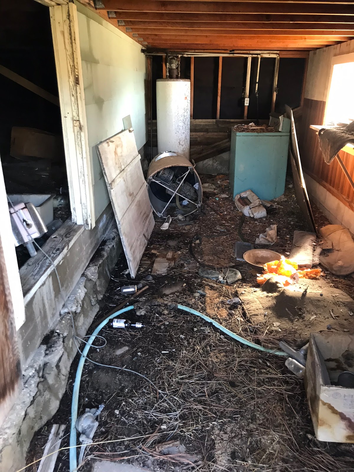
Frank Knapp purchased the Kelly Ranch in 1962 and mentions visiting as early as the 1930's. The historical record on who exactly Kelly was and why he sold the property seems to be a bit sketchy. From some accounts Kelly may have operated a gas station and restaurant on the nearby Old Ridge Route from 1915 to 1933. In the early 30's Knapp and his former boss King Gillette(of yes the famous Gillette Razor blade) were searching for the legendary Los Padres Gold Mine. (Spanish Monastery were said to have found an ultra rich gold vein using forced slave Indian Labor). Gillette was obsessed with finding this lost mine and sunk his fortune into doing so. According to a former Knapp employee from the 70's Kelly was supposedly beaten by some guys badly in a horse pasture in 1962. Rumors speculate that maybe it was for information on the whereabouts of the Los Padres Mine. I won't go into detail here about the legend but the history of it and its location is fascinating. To this day it still has not been found. To add to the Kelly mystery a 1983 article in SCV history notes they could find no reference to any Kelly at all, except for Allen Kelly who was hunting Grizzly bears in 1889. There is reference to Annie Rose Briggs though said to be living at the property in the 1950's. (Some photos below of what's left of the Knapp ranch structures, click on any picture to enlarge them).

Side View of the main Newer looking house

 Front View of the main house and a look underneath 

 Living room and the kitchen 

Outstanding view from the living room down Cienaga Canyon

The stables on the western end of the property

Lots of irrigation and sprinkler systems running through this field adjacent to the main house

Knapp spent many years living secluded on the ranch with his animals. He spent much of his time hunting, fishing, tending his vegetable garden and finding Indian artifacts. Frank loved his ranch, when he first saw it sometime in the 30's gold mining he knew he would own it someday. Frank Knapp passed away in 1988 and left the ranch to his brother Joe who held the property til his death in 1992. Relatives then sold the ranch to the organization Friends of the Forest bankrolled by Rosie Greer. The United States Forest Service would then go on to acquire the Ranch from Rosie in a 200 acre land trade. (There are multiple worn down structures still standing on the property see more photos below. To make these easy to identify on the included map I have attached my own label name to them).

The Third house

Third House kitchen

Small Cabin

First Ice can style stove I have seen of this size in the small cabin


Second really old looking house

Peak inside of the second house

The workshop/shed


Small Bunkhouse 

The Water Tower

While at the property we decided to add a few extra miles to our trip by heading deeper down into Cienaga Cyn.(This was a bushwhack). Below the main ranch are multiple fenced in areas that looked to be used for grazing. Even further on Cienaga Canyon trail passes nearby an Indian Burial Site. Stories of malevolent Indian spirits guarding lost gold mines in the area are not uncommon. The man who originally found the burial site was later severely injured in a motorcycle accident along the trail and Hugh Blanchard describes a report from a forest service worker and his female Native American companion about her insisting they turn back back from a hike toward the mines as she was getting a very uneasy and disturbing feeling of some sort of evil or unfriendly presence. 

Map of Structures on the property
If you found this write up interesting and would like to pay a visit to the Ranch here is one way you can do so. From the Santa Clarita Valley head North on the 5 freeway to the 138 East. Take Old ridge route for a little over 3 miles to its junction with Forest road 7N23 and park here. (N34° 42' 56.8" W118° 42' 39.1"). Warning be careful heading in on Old Ridge Route this time of year as you can see from the photos below the road can be icy and surrounded by snow especially in the morning. High clearance vehicle is best. (By midday when we left all the ice and snow had fully melted away).

Decent amount of snow and ice in the morning heading in

Park here on Old Ridge Route, your hike on foot takes off  between the 2 signs along Forest Route 7n23

Once parked leave old ridge Route and follow Forest road 7n23 uphill a very short distance to it's locked gate. Pass through the locked gate and continue along, at about .6 of a mile you will arrive at the junction with forest Road 7n22. Keep right and head onto 7n22. 

Keep right here and onto Forest Rd 7N22

Really neat Rock formation seen from along Forest Rd 7n22

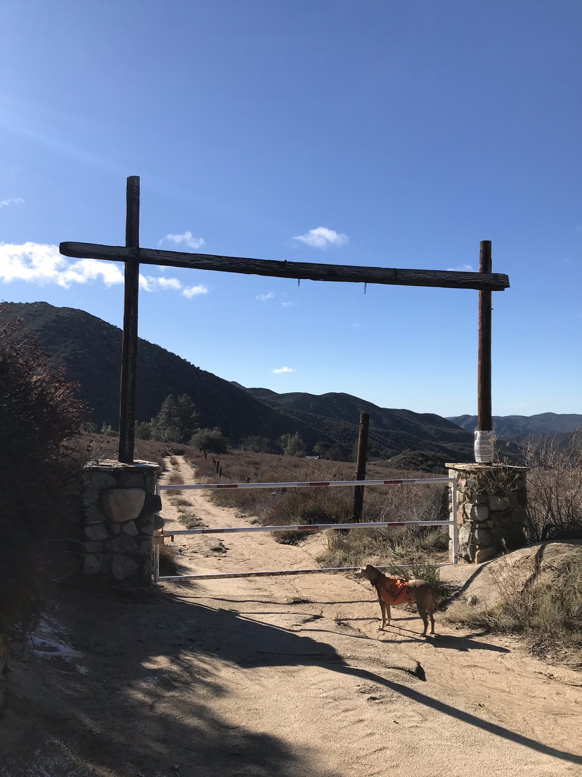
Front gate entrance to Knapp Ranch

From the parked car to Knapp ranch is about 5 miles. Mostly downhill all the way in with some decent elevation gain on the way out. My day finished at just under 14 miles however we explored further down the Canyon. For an out back just to the Ranch you're looking at just over 10 miles. The entire Hike follows forest roads until reaching the ranch so the trail is in good shape and easy to follow. Get out there and have a look! Extra adventurous folks might even try finding Gillette mine which should be about another 2 miles further from the ranch. (KMZ file and GPS track available for download below the google map).


Download KMZ File (Google Earth)

Monday, January 28, 2019

St Francis Dam Disaster Site

The St Francis Dam

The St Francis Dam was the brainchild of William Mulholland. General Manager and chief engineer for the Los Angeles Department of Water and Power (at the time named Bureau of Water Works and Supply). This concrete gravity Dam was built and designed between 1924-1926. The new Dam was to be a storage reservoir for the rapidly growing city of Los Angeles. Mulholland believed it was important to have this backup water supply should extended drought or damage occur to the Aqueduct. A site was selected 10 miles north of Santa Clarita in San Francisquito Cyn. Mulholland was a smart man and already famous for his design and construction of the 233 mile Los Angeles Aqueduct. An engineering marvel, and at the time the longest of its kind using gravity alone to propel water from the Owens Valley to Los Angeles. (This Aqueduct is still in use today). After extensive testing was done on the San Francisquito Cyn area final construction was carried out by Stanley Dunham and crew. 

The dam after the collapse
This section was named the "Tombstone"

Two and a half minutes before midnight on March 12, 1928 the 185-foot high Dam collapsed sending over 12 billion gallons of water roaring through San Francisquito Cyn and on through the Santa Clara River Valley 54 miles until finally emptying into the Pacific Ocean. Over 450 lives are estimated to have been lost in the flood. The destruction triggered numerous power outages and the shear force of the water destroyed anything in its path. Giving you an idea of the forces at work here A 10,000 ton piece of the dam was carried 3/4 of a mile below the site. First casualty was most likely the dam keeper caught in the 140 high initial wave that crushed his cottage just below the dam. His body and his 6 year old sons body were never found. 1.5 miles downstream Powerhouse #2 was hit and destroyed by a 120 foot wave travelling roughly 18 miles per hour, 64 men and their families who worked and lived nearby were killed as well. Extensive damage was done too Saugus, Valencia, Newhall, Castaic, Filmore, Bardsdale and Santa Paula. South of Ventura debris and victims were emptied into the Pacific. Some bodies were found as far south as the Mexican border and many were never recovered. A horrible tragedy indeed this was.

Concrete Block found half mile below the Dam

From investigative reports at the time I reckon that no matter how well the dam was constructed it most likely was gonna be a ticking time bomb destined to fail. In short Parts of the foundations were placed upon red conglomerate rock, much more easily erodible than solid bedrock. Below are the report conclusions word for word that can be found on Wikipedia. 
  1. The type and dimensions of the dam were amply sufficient if based on suitable foundation.
  2. The concrete of which the dam was built was of ample strength to resist the stresses to which it would normally be subjected.
  3. The failure cannot be laid to movement of the earth's crust.
  4. The dam failed as a result of defective foundations.
  5. This failure reflects in no way the stability of a well designed gravity dam properly founded on suitable bedrock


Visiting what now remains of the Dam today makes for a great family friendly Hike. There are multiple mileage options to suit everyone's needs. The walk out and back from the upper parking area can be done in under a mile. From the Lower lot one can make it a 3.2 mile round trip or a 1.6 mile shuttle if you have a vehicle parked on each side. (See Map below for way-points and location).

Lower Parking Turnout 

Upper Parking Turnout.
St Francis Dam sits along an old abandoned  section of San Francisquito Rd. The photos above show the parking turnouts and white blockades that keep out vehicle traffic. Not interested in walking, no problem bring your bicycles the old road is still in good enough shape to ride on. 

Follow the debris field across the western section to the hidden register

My daughter standing atop the western Dam section looking toward where the "tombstone" once stood
Before Beginning the hike down or up the old Road I highly recommend walking across the top Western section of the Damn. This affords outstanding views of the surrounding area and down toward what was the curved section of the Dam that blew-out. It's also fun to explore the rubble up here and sign the hidden Dam register while your at it. (Please leave all contents you find in the metal box). To access the western section there are two turnouts off the main San Francisquito Hwy just before the  upper parking turnout. Both have spur trails that will lead you up to the top. The sections are very short but steep. After visiting the western section return to the car and proceed to either the lower or upper Parking area to begin your hike. (Again map below has all relevant way-points).

Hidden Register

Heading down the old road from the upper parking area

Besides visiting the old Dam there are other interesting features along this hike. Make sure to visit the flowing creek and large pool that sits hidden off the trail on the east side of the Dam. As you can see Lot's of disappointing paintings on the rocks next to the plunge pool. Please don't contribute to the vandalism going on here.

The Creek was flowing

secluded pool on eastern side of the Dam,


A short distance below the dam you will cross over an old bridge if you look west you can spot 2 white Memorial crosses near a big boulder section that broke off and was washed downstream. I reckon this was near the area where the Dam keeper once lived.

White memorial crosses placed near large boulder section of the Dam

Haylee with grandpa under the bridge

There are also two nice memorials to see on your drive up the Canyon, one placed at the Fire Station and one at Powerhouse #2. Stop in to see the old photos and read a little bit of the history if you have time.
Memorial at the Fire Station just below the Dam

Memorial at Powerhouse #2

This was definitely a nice little outing with the family, got some exercise and learned a few things. If your a historical nerd like myself I think you would enjoy this one. Lot's to explore and so close to home. Another fine outing in the Angeles National Forest. 

Monday, January 21, 2019

Potholes to Agua Blanca Loop

The Pothole and Devils Potrero pictured above
The Devils Potrero Loop can begin at the Potholes Trailhead (18W04) or the Agua Blanca Trailhead (19W10). Access to these Trailheads can be a bit of a pain in the ass as both are situated along the now closed Piru Canyon Rd (4N13). The closing of Blue Point Campground in 1999 to protect habitat for the Arroyo toad pushed Potholes Trailhead access back 2.8 miles to the Gate at the Juan Fernandez boat launch at Lake Piru. To further complicate things extreme low water in the lake has closed this boat launch and pushed access back another 1.5 miles to the Visitors Parking area Adjacent to Reasoner Cyn. So plan on about 4.5 extra miles to the Potholes Trailhead and around 7 extra miles if your starting on The Agua Blanca Trailhead at Kesters Cabin.

Lake Piru Guard Shack

Deer at Temescal Station
Day use parking at Lake Piru is 10 Bucks. If no one is at the guard shack in the morning you can fill out the slip and pay the iron ranger. Temescal Forest Service Station is also here just west of the guard shack, almost always you will be greeted by the family of resident Deer that hang out here at the station. Once through the main gate drive all the way back to the visitors parking area pictured below.

Parking area Coordinates  N34° 28' 48.3" W118° 46' 14.5"
To get this loop done in a day without making it tougher than it already is I recommend bringing your bicycles. We rode our mountain bikes from here 4.5 miles along the paved road and stashed them in the bushes at the Potholes Trailhead. There are great views along this stretch of road of the Piru Canyon drainage, Lake Piru and its surrounding peaks. Immediately after getting out of the truck we were greeted by a small family of Coyotes who howled at us for a couple minutes. In less than a mile down the road we also saw another large family of deer and the resident cows. 


 One of the advantages to the access issue here is the area sees little traffic which gives it that wild and remote feel. Besides a few volunteers who help maintain the trail this area is mostly ignored and forgotten by most hikers. Fun Facts there was once more to this area than meets the eye. You may have noted just before you reached the parking area a locked gate on your left to Dominguez Canyon. Before the private property closing, Road (5N02) lead you to Dominguez Campground and further to Rodeo Springs Trail (18W08). Both of which have fallen from current maps. Also the mouth of Reasoner Canyon west of the parking area was the Starting point for Forest route (18W07) as pictured below from the 1967 LPNF Map. I do plan on further exploration of these decades old routes.

1967 LPNF Map showing Rodeo Springs and Reasoner Canyon Trails.
Piru Creek Drainage & Whitaker Peak looming in the distance
At about 4.1 miles in along the paved road there is a small spur trail that leads you down to the memorial of  Juan Fustero.  Born on the Temescal Ranch in 1841 Juan was the last Full blooded Tataviam male of the Piru Indians.

Juan Fustero memorial plaque
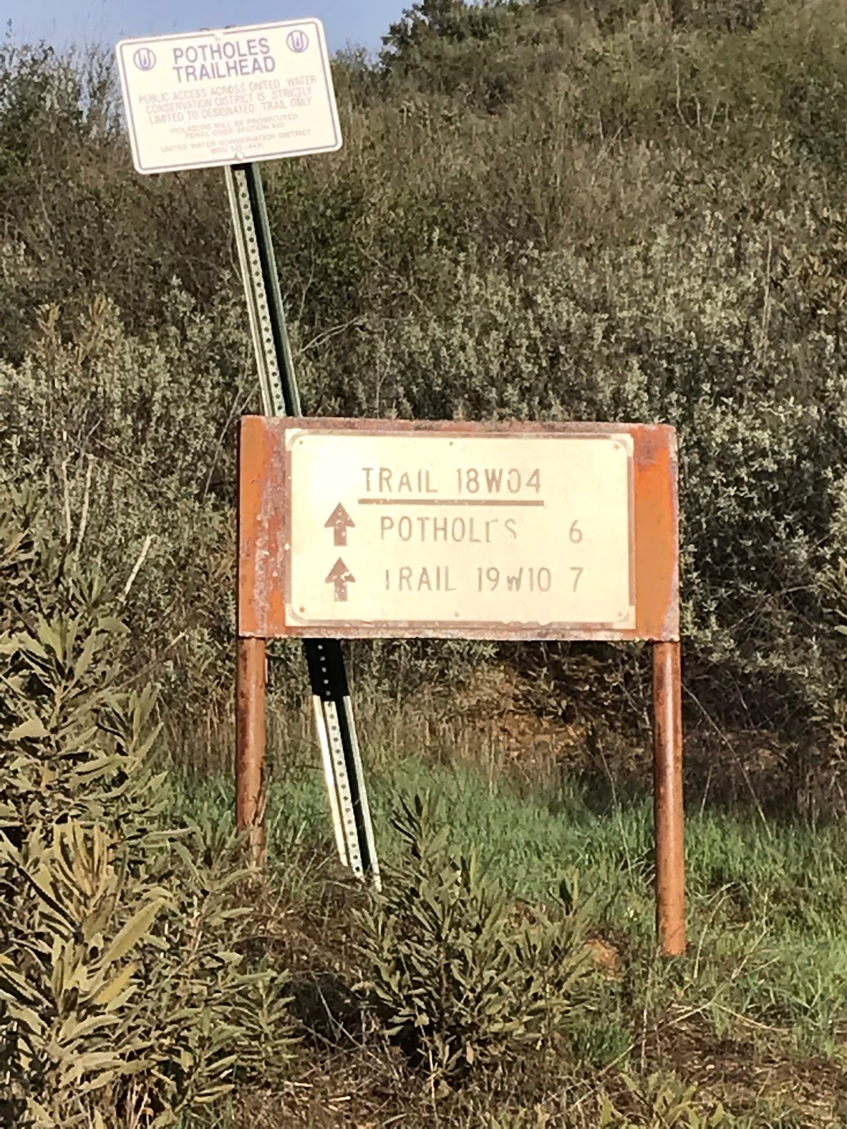
Back on the road and in about .4 miles from the memorial Plaque you will arrive at the Potholes Trailhead. Just after the bend in the road keep an eye to your left for the Trailhead Sign. 

Potholes Trailhead Junction sign
Jeff heading up through the meadow
From here and for the next 2.5 miles it is a beast of a grind up though the grassy meadow to the top of the ridge. You will gain a little over 2100 feet of elevation. For not getting much use the Potholes trail is well defined and easy to follow all the way to its northern terminus with the Agua Blanca Trail. This stretch toward the ridge has outstanding views of both the Agua Blanca drainage and the Piru Creek Drainage. Blue Point, Cobblestone and Whitaker peaks also dominate the scene. In the summer this trail is hot, exposed and most likely tick ridden through the lower meadow reaches. Right now we had none of that. This makes for a fantastic winter hiking spot. The current rains also brought out a whole host of different mushrooms, most variety I have seen at one time. Some edible, others not so much. Jeff snacked on a few along the way. DON'T EAT WILD MUSHROOMS unless you're absolutely positive of the variety. Eating the wrong mushroom will KILL YOU. I will refrain from posting any mushroom pics so as nobody accidentally eats the wrong one.

Views toward the Agua Blanca

 At the top of the ridge and about the 7 mile mark is the Potholes Sespe Wilderness Boundary sign. Here the trail turns North and you begin the descent down toward the pothole and the devils Potrero. Unfortunately all that elevation gained is given right back.

The Pothole

Another view of the Pothole
The Pothole is a unique geological depression from an ancient landslide caused by shifting underground faults. Cottonwood groves have taken up residence here, along with many weeds and brush. The Devils Potrero is the grassy meadow northwest of the Pothole. The trail winds down toward the pothole and eventually through the Devils Potrero. If you want to visit the pothole you will need to exit the main trail. 


Devils Potrero
After you have had your fill exploring the area around the Pothole and the Potrero keep heading north on Potholes trail. In a very short distance your will see a very old rusted no trespassing sign and what remains of a barbed wire fence. 

No Trespassing sign
At the 9.4 mile mark and my favorite part of this hike you arrive at the Whitaker Cabin Site and the unofficial Pothole Spring Camp. In the late 1800's William Whitaker purchased 80 acres of land and built his small farming cabin here adjacent to the spring. 


 Old farming equipment lies strewn about the landscape, all of which was dragged up here by mule. The cabin is still standing, though not in the worlds best condition. There are 2 rock fire pits and the area is completely shaded by large Oak trees. The spring had water flowing as did the adjacent creek leading down to the Agua Blanca. I absolutely love exploring these historical sites. With this particular one being only 1 mile from the Agua Blanca junction I would much rather prefer to stay the night here as opposed to the little more frequented Log Cabin Camp. Included below are a few shots of the inside of the cabin. The site is most likely still in the hands of private property, if you pay a visit here please be nice.


 Originally the plan was gonna be to get to Log Cabin Camp survey it and return the way we came. However we decided instead to exit down the Agua Blanca and complete the loop. Jeff had not been through the area yet so I was happy to give him the tour. Water is really flowing through Agua Blanca Creek right now. I knew I would be getting wet but did not expect to be waist deep at the lower road crossings with the Piru Junction. Keep that in mind if your heading up.

Agua Blanca Is a flowing

Junction with Potholes and Agua Blanca Trail

As mentioned above after leaving the cabin it's about a mile to The forest service Log Cabin camp. You will cross Agua Blanca Creek and hang a left at the junction sign pictured above onto Agua Blanca Trail (19W10). Continue a short distance further and you come to another sign signifying Log Cabin Camp in 200 yards. (pictured below).You might notice the odd position of this sign as it appears on your right side and facing toward the mountain side. The reason for this I believe is the original Agua Blanca trail directed you up and over the hill so as to bypass walking through the devils gateway just below. Currently that section is washed out and no longer maintained so its standard practice now to just chug along through the Creek.


Log Cabin Camp is the first designated Forest Service Trail Camp you will find coming up from the Agua Blanca. Originally 4 sites, BBQ stoves, rock fire pits and Ice can stoves are available for use.  The area is large and will accommodate a good amount of tents. As far as privacy is concerned it is probably best used as 3 sites now. With the first site being the nicest. Oaks provide plenty of shade and water is readily available from the creek. As the name would suggest there was once a Cabin here now long gone. I included a few shots below of the Camps site amenities. To  my surprise on this day we did find some campers here.

Log Cabin Camp site #1

Log Cabin site #2

Log Cabin site #3
After leaving Camp we headed back past the potholes junction making our way through the devils gateway and down the Canyon. The trail is in pretty good shape and mostly easy to follow. The hardest parts are some of the creek crossing where you may lose the trail. Look for flagging in the trees marking the crossing points. With a little keen observation you will always find the trail to pick up again. I noted only 2 downed trees across the trail below Log Cabin Camp.

Devil's Gateway
The Agua Blanca Canyon is one of the most scenic places in the Ojai Ranger district. A truly wild and remote experience. This section of the forest never gets old to me. I tried vigorously in the beginning every trick in the book to not get my boots wet and was successful for a time being but that eventually ended with a slip into knee deep water. So yeah wet boots it was for the remainder of the trip.
Me trying hard at first not to get wet
At the 12.6 mile mark we came upon the Agua Blanca Sespe wilderness sign. This sign has a special place in my heart as I helped install a new 4x4 post on it some time ago. Glad to see it was still in good shape. Even complete with new bear claw mark. 

Agua Blanca Sespe Wilderness Sign

Kesters Cabin
From the Wilderness sign it's just over a mile to Kesters cabin. You will need to pass straight through the middle of this private property. Here roughly marks the lower Agua Blanca Trailhead. After the Cabin follow the dirt road around the bend and south to Whitaker Ranch. (Joe Ritchey's Cabin). Right now the multiple road crossings before reaching Blue Point are raging . We had swift moving waist high water. Use extreme caution when crossing these spots. 

Whitaker Ranch

Jeff Navigating the easiest of the crossings
Heading toward Blue point the area has some really nice wind eroded caves to explore. Stumbled upon a geocache below one of the openings. Passing Blue point I noticed the picnic table and restroom site along the road is now gone. Looks like some decommissioning has taken place since I last went through. Back on the paved road it's only another 1.5 miles to the Potholes Trailhead and where we left our bikes to complete the loop. 

Wind Caves North of Blue Point can you spot the geocache ? 

Not much left of Blue Point Campground along the road
To recap this was a long day but a good one. My heart has been here in the Piru Backcountry ever since I through Hiked the Creek a few years back. Its Peaceful, remote and beautiful country. Don't let the lack of access prevent you from visiting the area. Total mileage for the day was just under 22. With 9 miles on the bikes and about 13 on foot. I hear whispers that eventually they will be opening up the road to Potholes Trailhead. I do hope this comes to be. GPS Track and KMZ file included for download under the map.