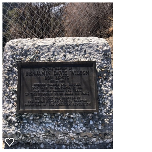
Sitting at home nursing my broken ankle I came up with a grand idea. I decided I'm going to attempt to hike all or most of the Sierra Clubs Hundred Peaks Section Hikes. Which consists of about 275 named summits in Southern California. Stretching from Kern County down to San Diego. From here on going forward every chance I get I'm gonna try to check one of these Summits off my list, and hopefully some day put my name in all the registers that sit on top of these peaks. I also would like to document each one of them here on my blog so I will start with MT Wilson which I completed back in April of 2018. If you would like to read more about The Hundred peaks section here is a link to the website. http://www.hundredpeaks.org/
MT Wilson is a peak in the San Gabriel Mountains located within the Angeles National Forest in Los Angeles County. The summit sits at 5,710 feet and is home to the Mount Wilson Observatory. There are quite a few different ways to the top I choose to start from Chantry Flats Trailhead above Arcadia.
From the 210 Freeway exit Santa Anita Ave. Drive North 5 miles to Chantry Flat Parking.
The gate up here opens at 6am, you need an adventure pass to park here unless you park at Adams pack station which will cost you 10 bucks. This place is extremely popular and gets jammed packed so ARRIVE AS EARLY AS POSSIBLE. Restrooms are available in the parking area and near the Trailhead. There is also a general store at the pack station to buy ice cream, soft drinks or cold beer. :)
The Gabrielino Trail starts just below the parking area on a paved road. follow the trail to the bottom and cross the bridge. Along the route you will find a few pit toilets but they are dirty and in need of major cleaning. If you have time when you come to the junction for Sturtevant Falls, I highly recommend you take the 1 mile out and back detour to visit it.
After Visiting the falls head back to the junction you came from and back onto the Lower Gabrielino trail. ( There is an upper trail but its not as scenic so iv'e heard) Follow the Creek up and through a beautiful shaded canyon, dotted with private cabins and camp spots along the way. I must say I was very impressed with the scenery along this whole route, it made me feel at times that I was back hiking in mammoth and not LA County. Around 4 miles in you will pass Spruce Grove Trail Camp.
Probably not even a half mile past Spruce you will come to Sturtevant Camp. This was quite a welcome surprise for me as I didn't even know this place existed. This was cutest collection of cabins that can be rented by the general public the mules at the pack station will even carry all your goods up to the cabins for a small fee. This place is steeped in history and offers visitors a chance to go back in time and enjoy some old fashioned cabin camping. If you would like to learn more about this place here is the link to their website. http://sturtevantcamp.com/
Continuing on past the camp On the Sturtevant Trail from this point up I really started to notice the climb. This second half is much harder than the first half. within a few miles you come to some relentless switch backs gaining a 1000 feet of elevation in a short amount of distance. To me this second half was definitely more remote and is where I really enjoyed my surrounding's.
If you come on the weekends there is a lot going on once you reach the top. The museum was open and so was the cosmic cafe when I went. It was really nice actually to sit down and have an ice cold gatorade and some chocolate chips cookies from the cafe. I was tempted to get a cold beer and slice of apple pie but figured I don't wanna be to to full for the journey back down.
After a quick break and a bit of exploring at the top I headed off. I choose not to go down the same way I came up. Instead I followed Mt wilson Road to the junction of winter creek trail.
Travelling Past Hoegee's Trail camp I took Lower winter creek Trail following the water. You can choose the upper or lower trail to get back to Chantry Flat. The lower trail does drop you a half mile below Chantry but I prefer to travel along creeks so I'm okay with the small bit of uphill at the end. Once back at the car I dropped my bag and went and visited the store at Adam's pack station and browsed the collection of maps and souvenirs. Another great day in the books. If you attempt this hike you should be in decent shape as its very strenuous. You will gain around 4200 feet of elevation and round trip will be just under 14 miles. Expect to be on the trail for at least 6 hours. carry a map and or GPS and know your route ahead of time. If you make a wrong turn up here you can end up lost after dark deep in the wilderness. Feel free to reach out should you like to join me on the Hundred Peaks challenge of trying to get to the top of them all.
Download GPX Track (GPS Units)
Download KMZ File (Google Earth)


No comments:
Post a Comment